SKEALS
Spurn Kilnsea and Easington Area Local Studies
SPURN POINT
The history of the peninsulas at the tip of Holderness
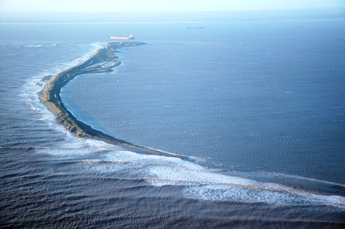
Spurn Head, or Spurn Point, the present peninsula at the southern tip of South Holderness, is a three-and-a-half-mile line of sand and shingle, which stretches out between the North Sea and the River Humber in a south-westerly direction. A peninsula in one form or another has existed here since the first one was formed after the retreat of the ice at the end of the last Ice Age. How such a peninsula comes into existence and how it develops and changes cannot be certainly proven. Its course is not fixed, because it is attached to one of the fastest eroding coasts in the world — the Holderness coast.
One theory, supported by historical records, postulates a cyclical history of about 250 years for each of the various peninsulas, which have grown gradually as a result of long-shore drift of material washed out of the clay cliffs to the north. The profile of each peninsula, which grows from a stump, is low, allowing a certain amount of wash-over of sand, which helps to build it up on the western side, whilst most of the material moves further south and forms a spoon-shaped point. With the rapid erosion of the coast to which it is attached, a breach is inevitable eventually, and once the sea gets through, the head becomes isolated and gradually washes away. A new peninsula then forms a little to the west and the cycle starts again.
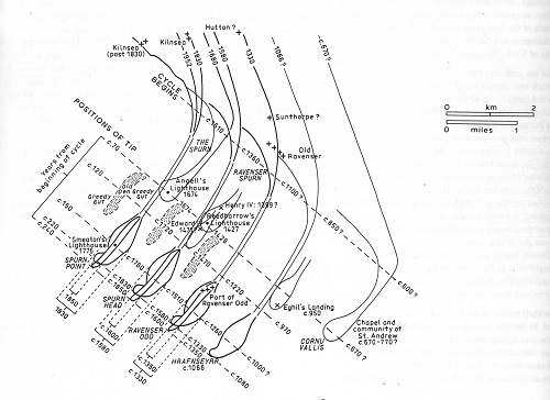
George de Boer’s theory of various peninsulas
Another theory gives more emphasis to the wash-over of the neck, and suggests that as the sand and other material is transported from east to west, the neck gradually shifts westward, presumably moving the head with it. It is not possible to test these theories thoroughly because since mid-Victorian times Spurn has been kept in place by artificial coastal defences, begun after a massive breach which took place in 1849, when the peninsula was composed of a string of islets.
The groynes and revetments to protect the peninsula were first erected in the later 19th century by the Board of Trade, but when military forts were established on the Point (see below) the Army took over, with the Royal Engineers, and later civilians, working upon the maintenance of the sea defences, until the departure of the military in the late 1950s.

Roland Cooper and mate working on the groynes in the 1950s
These artificial sea defences have resulted in the peninsula now being longer than ever before and retaining unchanged the same alignment since the 1850s, as a result of which it has become highly vulnerable to attacks from north-westerly tidal surges in the North Sea.
For centuries Spurn was owned by the Constable family, the Seigniors of Holderness, who lived at Burton Constable. When the War Office wished to establish Spurn Fort to protect the Humber in World War I, it leased the peninsula from the Constables, and in 1925 the War Office bought it from the Constables by compulsory purchase. Between the wars only a few military personnel remained at the Point. Spurn Fort was re-armed and manned during World War II. While the army was in control, the sea defences were well maintained, and after the war most of the personnel who remained were busy on that work.
During the period of international East-West tension known as the Cold War in the early 1950s, Spurn’s role in coastal defence was reassessed, and for a while the military returned, and even built new hutments near the Warren.
However, by about 1956 the Ministry of Defence had decided that Spurn no longer had any useful military role, and prolonged negotiations began with interested parties concerning its future. The Yorkshire Naturalists’ Trust (now the Yorkshire Wildlife Trust) was interested in establishing Spurn as a nature reserve, whilst other, mainly local people wished to buy it for development as a recreational facility, probably a caravan or chalet site. In the end the Yorkshire Naturalists’ Trust bought Spurn in 1959. The Trust could not afford to maintain the defences, and they are now crumbling away. By the early years of the present century, at the northern end of the peninsula only about three yards (or three metres) of land separated the high tide mark on the Humber from the high tide mark on the sea. Various wash-overs of the road have damaged sections, until as a result of the North Sea surge on 5th December 2013, a breach occurred in the peninsula, and the road at the northern end was destroyed, so only official vehicles can now drive down. However, it is still possible to walk or cycle to the Point.
The wash-over of the Spurn peninsula, December 2013
The Lifeboat
Since 1810 Spurn has been the base of the Humber Lifeboat. Established at the end of Spurn Point because so many ships were being wrecked on the Stony Binks, the lifeboat has had many distinguished coxswains and crew, who have been involved in numerous dangerous rescues. Between 1810 and 1910 the lifeboat was operated by Hull Trinity House, and after that date by the Royal National Lifeboat Institution (RNLI). The lifeboat is manned by the only full-time permanent crew in the British Isles, and from 1819 until 2012 the peninsula has been home for both the lifeboat crew and their families. When the families were forced to leave, because of the difficulties of access, the manning of the lifeboat had to be changed, and now two crews alternate. This is a massive change for Spurn, because the presence of families on the peninsula had made it a very lively place.

Robert Cross (front) at a medal presentation in London with other lifeboat members from around the country receiving their medals
The first houses stood on the Humber side of the peninsula not far from the lighthouse. In 1857 they were replaced by a new terrace of houses on a site now taken up by the Point car-park. In 1890 a school was erected nearby, and Spurn children were educated there until 1945, when the school was closed and the children were taken daily to Easington. In 1975 the families moved into modern houses a little further down the Point. Those houses are still used for crew accommodation.
Maritime matters
The Humber is a very dangerous river with constantly changing currents. In the 16th century Hull Trinity House controlled navigation on the Humber, providing beacons, buoys and lightships, as well as licensing pilots, overseeing the management of Spurn lighthouse, and managing the Spurn lifeboat. After 1800 the pilots became the Humber Pilots Commission, and in 1908 they came under the jurisdiction of the newly formed Humber Conservancy Board, whose powers were in 1968 transferred to the British Transport Docks Board, and in 1981 to Associated British Ports (ABP). Until 1975 the pilots worked from a vessel moored off Spurn but, in that year, they moved to a shore base on Spurn itself, established in one of the old World War I buildings on the Point, and a jetty was constructed for the pilot boats to work from. In 2013, as a result of the lack of road access, they moved their base to Grimsby.

Constructing the Pilots’ jetty, 1976
The Vessel Traffic Service (VTS), which monitors all shipping in the Humber, and is also controlled by Associated British Ports, ran a 24-hour watch across the mouth of the Humber from a tower established on the base of a former Battery Observation Post on the Point until 2013, when the service also moved to Grimsby. Many changes for Spurn over a few years!
Spurn’s military role
Positioned strategically at the head of a busy estuary, Spurn Point has played an important role in the defence of Britain. During the Napoleonic Wars a battery with barracks was established there about 1805. At the beginning of World War I, when the military authorities were considering how to defend the Yorkshire coast and the River Humber, Spurn seemed an ideal place to put land-based defences, despite the obvious problems of constructing heavy buildings and armaments on sandy soil.
Accordingly, in 1915, Spurn Fort (which incorporated Green Battery) was established on the Point. A little further up the peninsula, near the lighthouse, the Port War Signal Station was built. From here all vessels using the area were monitored; they used pennants, lights and sound to indicate that they were friendly vessels. At the mouth of the estuary two forts, Bull Sand Fort and Haile Sand Fort, were erected on sand banks.

Haile Sand Fort
At the northern end of the peninsula at Kilnsea, Godwin Battery, another fort, was built. During the construction of these forts, a military railway was laid down to link Spurn and Kilnsea. As a means of giving early warning of the approach of Zeppelins, the Kilnsea Sound Mirror was erected in fields a little to the north of Godwin Battery. At this time the Army took over responsibility for maintaining the sea defences from the Board of Trade.

Bull Sand Fort
After the war the forts were placed under a system of care and maintenance, whilst Godwin Battery was retained as a local military base, and also used by the Territorial Army for annual camps. In 1933/34 most of the soldiers left Spurn itself, and civilians were employed to care for the camp and maintain the sea defences.
When World War II was declared, the military came back in force, and in the early years of the war Spurn played an important role in home defence. When the focus of the war moved to the Continent, Spurn and Kilnsea forts continued to play an important role in the defence of the East Coast from the air. After the war a military presence remained, and in the 1950s during the Cold War, more anti-aircraft artillery was placed in the Warren area. The accommodation on the Point was also used by the R.A.F. until they transferred to a new base at Patrington Haven.
By the late 1950s most of the military had withdrawn and the forts were put up for sale. In 1959 Spurn itself was sold to the Yorkshire Naturalists’ Trust for the creation of a nature reserve and in 1960 Godwin Battery was sold and turned into a caravan site (Sandy Beaches). Some military buildings, gun emplacements, and concrete pill boxes still remain, though many were demolished in the 1970s because they were thought to be dangerous. On the beach in front of Sandy Beaches Caravan Site lie two huge gun emplacements, and more military buildings have toppled over to join them.

Gun emplacement on the beach, 2004
On the Point itself it is still possible to see searchlight emplacements, the remains of an engine room, two large gun emplacements, and other relics which give an indication of what Spurn must have looked like when it was bristling with armaments and soldiers. Some military buildings and tunnels have been made accessible by the Yorkshire Wildlife Trust and are well worth a visit. In the estuary the two forts, Bull Sand Fort and Haile Sand Fort, still stand grey and forbidding, like sentinels at the mouth of the Humber.
The Lighthouses
Lighthouses have been located on Spurn for over five hundred years. The first reference to a lighthouse on Spurn dates back to 1427, when a hermit, William Reedbarrow, was granted dues from passing ships to complete a lighthouse which he had begun to build there, though little further is known about it.
In the late 17th century a high and a low light were erected on what was then the tip of the spit, probably about two miles north of the present tip. The low light had to be rebuilt several times, but the high light lasted until the late 18th century, when John Smeaton, the celebrated engineer who had built the Eddystone lighthouse in 1759, designed and built two new lighthouses, under the direction of the Hull and London Trinity Houses.
In 1852, a new low lighthouse was built on the Humber foreshore, and in 1895, because there was evidence that the foundations of Smeaton’s lighthouse were giving way, the present lighthouse was erected.

Spurn lighthouse, c. 1980
With the building of the new lighthouse, which emitted fixed beams of light from various levels, the low lighthouse became redundant, and was used first as an explosives store, and later for water storage, when it was ‘crowned’ by a large tank, which still remains. The high lighthouse shone out over Spurn (apart from during war-time) for 90 years, until in 1985 modern technology made it redundant. In 2014-15 the Yorkshire Wildlife Trust received a grant of half a million pounds from the Heritage Lottery Fund, and the lighthouse was renovated and is now open to the public at weekends.
The Warren and Warren Cottage
From mediaeval times an area of land to the south of Kilnsea’s southern-most arable field (South Field) was known as Kilnsea Warren. It was common land, occupied by scrub and containing several meres, as well as a rabbit warren. Until the beginning of the 19th century rabbits were ‘farmed’ for their flesh and fur, and there were many such enterprises in East Yorkshire. Old maps also show that part of the peninsula between the lighthouse and Chalk Bank as “Spurn Warren”, so presumably a warren was also established there. Spurn’s rabbits are probably direct descendants!
A cobble cottage was built c. 1859 for the shore bailiff who collected the dues from gravelling for the Constable family who owned the peninsula until 1925. In the 1880s until c. 1905 it was rented by Colonel William Lambert White of Hedon as a shooting box, and his gamekeeper seems to have lived there when the White family was not in residence.

Warren Cottage c. 1930
In the 1920s it was described as ‘ruinous’ but was occupied again before World War II. During the war it was used by the military and in 1945 Ralph Chislett negotiated to rent it from the War Department as the headquarters for Spurn Bird Observatory.
Near Warren Cottage two bungalows were built in 1953 for the men who looked after the new anti-aircraft guns which were installed at the Warren during the Cold War. After they left c. 1956 it remained empty until Spurn was bought in 1959/60 by the Yorkshire Naturalists’ Trust, later the Yorkshire Wildlife Trust. The first warden, Peter Mountford, lived there in 1960/1 and Spurn Bird Observatory took it over as an extension of its accommodation c. 1963. Another building nearby became the Information Centre.
The situation now is much changed. The military buildings have all been removed by the Yorkshire Wildlife Trust. Spurn Bird Observatory has a new building in Kilnsea (see below). The history of the Warren area has been covered in two articles which can be accessed on my web site www.wilgilsland.co.uk, under the page entitled Jan’s publications.
Spurn Bird Observatory
The unique landscape of Spurn Head, and its distinctive flora and fauna have attracted naturalists to the peninsula since the early 19th century. Ornithologists like John Cordeaux, and William Eagle Clarke, spent much time at Spurn in the late 19th and early 20th century, and they were followed by Ralph Chislett, George Edwards, and George Ainsworth, to name but a few. In the 1930s some of these people realised that Spurn would be an ideal location for a bird observatory, and made plans to take a lease upon Warren Cottage, at the north end of the peninsula.
Unfortunately the war intervened and plans were put on hold, to be revived again in 1945/6, when Spurn Bird Observatory was born. Since then bird observation and recording on the peninsula has continued without a break. Ornithological activities include the organisation of ringing courses, migration watches of the Narrows, and regular patrols of the Observatory recording area. In recent years a Migration Festival has been held every September.
As well as records of birds, the Observatory daily log covers observations of the weather and sightings of unusual insects, mammals, and reptiles, and indeed any noteworthy feature or occurrence of natural interest. The importance of the peninsula for natural history was officially acknowledged in 1996 when Spurn became a National Nature Reserve. Spurn Bird Observatory is now located in Kilnsea, near the Crown and Anchor pub.

Spurn at eventide, 2004
Jan Crowther (2020)