SKEALS
Spurn Kilnsea and Easington Area Local Studies
AN ARCHAEOLOGICAL EXCAVATION AT EASINGTON
EASINGTON, ROUND BARROW & NEOLITHIC SETTLEMENT (TA 4087/1807)

Easington Barrow Location Map (Courtesy of Rod Mackey)
During the late summers and autumns of 1996 and 1997, members of the East Riding Archaeological Society (ERAS) led by Rod Mackey and Kate Dennett undertook two, eleven-week excavations on a round barrow at Easington, close to the mouth of the Humber. The site had been previously excavated by Rod Mackey in the 1960s and before that in the 1890s, by Dr. H. B. Hewetson of Leeds. In all, over sixty Society members were involved, often working in extreme weather conditions and having to contend with sand storms and tidal flooding.

Easington Barrow under excavation in 1962 (Courtesy of George Shepherd)

Wind blown sand covers the excavation (Courtesy of Rod Mackey)

Tidal flooding of the 1996 excavation (Courtesy of Rod Mackey)
The site was not accessible by road, which meant that in 1996 equipment and valuables had to be carried in wheelbarrows for over half a mile down the beach each day. In 1997, a shelter was built with scaffolding and plastic sheeting to provide a site office and store and a noticeboard was erected to explain the project to passing members of the public, who responded with great interest.
Round barrows are scarce in Holderness and this one is part of a small isolated group, some of which have already been lost through coastal erosion. By 1996 it stood on the beach and was clearly in imminent danger. The excavations were not funded, but BP Explorations and The Environment Agency did help with machinery to remove the previous backfill and to reinstate the mound afterwards. The ongoing post-excavation work has been helped so far, by small grants from YAS, The Robert Kiln Trust, CBA Challenge and The East Riding Archaeological Research Trust.
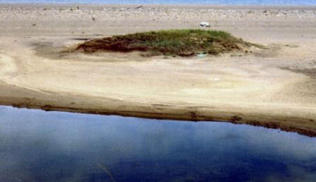
Easington Barrow on the beach in 1996 (Courtesy of Rod Mackey)
The 1890s Excavations
A series of parallel slots, cut into the natural clay beneath the centre of the mound, had been misinterpreted in the 1960s as the remains of a large timber structure. On re-examination in 1996, it became apparent that these were the result of Dr. Hewetson’s 1890s excavations. He had cut a 2½ metre-wide trench through the middle of the mound from the south, within which nine parallel slots had been dug, as a means of probing the natural clay in search of a burial. He had also cut two shorter trenches on either side, one of which had narrowly missed the grave found in the 1960s. J.R.Mortimer refers to the technique of probing with parallel trenches in his ‘Forty Years Researches’, and may even have been present at these excavations.

Dr. H.B. Hewetson, the antiquarian scholar who first investigated the Easington barrow in the 1890s
The Round Barrow
The shallow grave found in the 1960s was well off-centre to the mound. No trace of a skeleton had survived due to the highly acidic nature of the clay, but a large conical jet button, 60 mm. in diameter, turned and polished, lay inverted at the shoulder position. This may be the earliest example of turning recorded in Britain.
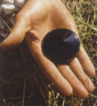
The Jet Button found in 1963 (Courtesy of George Shepherd)
An undecorated long-necked beaker, placed on the land surface by the side of the grave, had subsequently been crushed when the mound was heaped over it. Part of a finely-worked flint arrowhead was recovered from the 19th century excavation backfill and shards of a Yorkshire food vessel were found sealed beneath the mound. The grave lay at the apex of a low natural rise, but the barrow itself was centred well to the north-west. Charred brushwood, noted in the grave fill, also covered the sealed land surface in many places, suggesting an initial clearance by burning. Following the burial, charred oak trunks and heavy branches had been laid to form a circle, 14 metres in diameter, defining the area where the barrow would stand. The mound, which was originally about 16 metres in diameter, appears to have been built in two stages, with a core of sandy surface clay capped by the same material mixed with plastic clay from deeper levels. No trace of a surrounding ditch was found within the 8 metre perimeter examined. Alder, hazel, willow, poplar and oak were all identified amongst the sealed charcoal and seven radiocarbon samples have dated the barrow construction to the early Bronze Age, around cal BC 2000.

The 1997 excavation, barrow reopened (Courtesy of Rod Mackey)
Three charred grains of wheatbread, recovered from the site, gave a radiocarbon date between the mid-3rd and late 4th century AD, indicating that the barrow may have stood close to or within Roman arable fields at that time.
The Neolithic Occupation
The presence of a separate, earlier Neolithic occupation, sealed beneath the mound had been recognized in the 1960s. In the recent excavations, several hearths, pits and post-holes belonging to this phase were identified around the apex of the natural rise, together with a dense scatter of pottery (over 650 shards) and worked flint (over 750 items). Other post-holes, probably part of a long rectangular building were found just beyond the barrow on the south-east side. All of the pottery was heavily weathered due to long exposure on the surface prior to being covered by the mound. A large number of different vessels were represented, some plain, some decorated with grooves, stamps, cord or finger-nail impressions, and mostly of mid-Neolithic tradition. Much of the flint was waste material from tool-making. Narrow blades dominated the assemblage, but there were also scrapers, knives, part of a large polished adze and a tranché-type arrowhead (triangular with a single barb). One unusual scraper and one knife had been ground to a perfect edge. The occupants had mainly exploited the best quality black flint from the local boulder clay, which could have been collected from stream beds or the Humber shore. Fragments of several saddle querns and rubbing stones were recovered from one pit, and a fired clay loom weight had been used as packing in one of the post-holes. This may be the earliest loom weight found in Britain to date.

Fragments of a fired clay loom weight from the packing of a post-hole
A series of charcoal samples from a hearth and various postholes provided new AMS radiocarbon dates. Neolithic people had occupied the site for over a thousand years, from the early 4th millennium BC to the mid or late 3rd millennium BC. At that time, five thousand years ago, the sea may have been at least ten kilometres away to the east, but the Humber shore would have been almost as close as it is today. The settlement stood at the side of the Kilnsea Fleet, a broad valley running in a north-easterly direction from the estuary. A henge monument (see below) and several other round barrows occupied the same valley, which later became a tidal creek when sea levels rose. The continued importance of this inlet into the early Bronze Age was confirmed in 1996 when Society members found a fragment of a sewn-plank boat on Kilnsea beach. This was dated by radiocarbon to 1870-1670 cal BC, the earliest example in Britain. Sewn-plank boats are thought to have been sea-going vessels.
Subsequent Discoveries on Easington Beach
In June 1998, following information from the Spurn Heritage Warden, Society members investigated features on the beach at Easington, some 200-250 metres NNE of the barrow excavated in 1996-7. The sand had been scoured away by the tide to reveal a long stretch of underlying clay and mud; something which occurs periodically along this part of the coast. Two circular features were visible about 50 metres apart, both of which were drawn and photographed. Small sections were excavated between tides, and skeletal material together with the contents of a pit filled with charcoal and calcined bone were removed as a rescue precaution. As ERAS did not have the resources to complete the work within the limited time available, it was passed on to the Centre for Wetlands Archaeology at the University of Hull, who were then commissioned by English Heritage to undertake an assessment during August 1998.
The Henge Monument (TA 4097 1828)
The larger monument consisted of a series of concentric rings of gravel, estuarine clay and dark staining with an overall diameter of about 25-30 metres. A tracked 360° excavator was used to strip some of the overlying beach deposits and to cut three sections.

The henge explored in 1998 (Courtesy of Rod Mackey)
From the better preserved north-eastern quadrant it was clear that there were two concentric ditches. The smaller, innermost of these enclosed an area about 12 metres in diameter. It had a small internal bank and possibly an external one also. The pit containing charcoal and calcined bone, previously removed by ERAS, had been cut into the silty fill of this inner ditch. Subsequent analysis showed that it contained both human and animal bone, which may have continued to burn after being deposited. This cremation deposit was of a young man, who died around 2500-2000 cal BC. Black organically rich material had accumulated over a primary soil profile within the inner ring after its construction. Pollen samples taken from this, show that the inner monument was in use before the start of the known decline of lime trees in the first millennium BC.
The black soil was covered in places by a blanket of gravel, possibly a new surface created when the much larger outer ditch was dug, enclosing an area of about 20m. This second phase had a substantial outer bank with a possible entrance on the NNW. Unfortunately, the opposite side of the monument had been destroyed by marine inundation. This event had also filled the outer ditch with estuarine clay, at a time when the monument was still upstanding and perhaps not long after its construction, because there was little earlier terrestrial silting. A single sherd of Iron Age pottery, recovered from the surface of the ditch fill, supports a first millennium BC date for the inundation. All the evidence so far, indicates that the first phase of this monument would have been in use when the Easington barrow was built.
Barrow 2 (TA 4098 1822)
50m south of the henge, a second barrow, with an overall diameter of 17m. had been exposed close to the line of the old sea bank, washed away in the 1960’s. A ditch with an external bank enclosed a circular area of gravel 9m across with the bones of a crouched adult inhumation at its centre. The skeleton, lying on its right side with its head to the south-west, may have been buried in a very shallow grave or simply laid on the land surface beneath a mound. Shards of a Bronze Age collared urn were recovered from the same surface. Like the later phase of the henge, the ditch and bank of this barrow had been upstanding at the time of the estuarine incursion. External banks have not been recognized before in East Yorkshire barrows, but ploughing is likely to have destroyed much of the evidence elsewhere.

Barrow 2 - Easington Beach 1998 (TA 4098 1822) (Plan courtesy of Rod Mackey)
Like the Easington barrow, this barrow had also sealed evidence of much earlier Neolithic activity. Sherds of Peterborough ware and the remains of a hearth were found within its central area.
Relevant publications:
Evans.D.H, (ed.), - East Riding Archaeologist. vol. 10, 2001: 69-73 (interim summaries)
Dennett.K, - ‘Henry Bendelack Hewetson 1850-1899, a Renaissance Man of the Victorian Era’: in Leeds Museums & Galleries Review, No. 3, 2000: 17-23
Van de Noort.R, Middleton.R, Foxon.A & Bayliss.A, - ‘The Kilnsea–boat’ in Antiquity 73, 1999: 131-5
Faulkner, N. (Ed), - ‘A tale in three parts concerning a barrow, a long house and a henge’ in Current Archaeology No. 202, 2006: 526-31
Rod Mackey, Vice Chair, East Riding Archaeological Society
Lecturer in Archaeology (part-time), University of Hull
R.W.Mackey@hull.ac.uk
When specialist reports on the pottery, flint and querns are completed, a full report on the work at Easington will be published in a future volume of the Society’s journal ‘The East Riding Archaeologist’. The Society received a ‘runner up’ prize for the best project by a voluntary body at the British Archaeological Awards in 2004.
Note:
The East Riding Archaeological Society is the major public body for archaeology in the county of East Yorkshire and Hull. Founded in 1960, it has over 250 members, including most of the professional archaeologists and museum staff working in the area. It has strong links with Hull Museums and with Hull University, where it holds its programme of lectures. It has an active field study group and publishes a journal 'The East Riding Archaeologist'.
Application for membership can be made to the Treasurer, Leslie Jackson, 24 St. Stephens Close, Willerby, East Yorkshire. HU10 6DG
SKEALS would like to thank Rod Mackey for his kind permission to reproduce this report and for supplying the photographs to accompany this article.